One of the most common mistakes we see in Surprise is assuming that a gentle desert slope is inherently stable. The arid appearance of the White Tank Mountains foothills can be deceiving—underneath that sun-baked crust, the soil profile often contains layers of colluvium and weakly cemented alluvium that lose significant strength when water is introduced. A slope that has stood for decades can unravel in a single monsoon season if surface drainage isn't managed correctly. Before finalizing your grading plan or retaining wall design, a thorough slope stability analysis quantifies the factor of safety under both static and seismic conditions. We often pair this with test pits to visually log the stratigraphy and confirm the depth to caliche layers that can act as slip planes when saturated.
In Surprise's desert environment, a slope's stability is governed less by its dry condition and more by its response to a 100-year monsoon event.
Technical details of the service in Surprise Arizona
Local geotechnical conditions in Surprise Arizona
The surficial geology across Surprise consists primarily of Quaternary alluvial fan deposits, with increasing clay content as you move south toward the Salt River Valley. These expansive clays create a dual hazard: shrink-swell behavior that cracks the soil mass, and a dramatic strength reduction when wetted. We routinely observe that a slope cut at a 1.5:1 ratio in dry conditions will ravel and spall during August storms, progressively steepening until a larger rotational failure occurs. The Maricopa County drainage regulations require positive drainage away from all cut and fill slopes, but achieving this on flat-lying lots near the 303 corridor demands careful benching and subsurface drainage design. A slope stability analysis that ignores the perched water tables forming above caliche lenses will underestimate the pore pressure distribution, leading to a non-conservative design that puts future homeowners and infrastructure at risk.
Our services
Our slope stability assessments for sites in Surprise integrate field exploration, laboratory testing, and advanced numerical modeling to deliver a complete picture of the risk profile. Each scope of work is tailored to the specific topographic setting, from residential lots backing up to natural desert washes to commercial pads requiring deep cuts.
Static and Seismic Slope Modeling
We use 2D limit equilibrium software to evaluate circular, planar, and wedge-type failure mechanisms under both dry and fully saturated phreatic conditions, applying the pseudostatic coefficient specified in ASCE 7-22 for Maricopa County.
Monsoon Saturation Analysis
Transient infiltration modeling predicts how the wetting front advances through desert soils during a design storm, quantifying the loss of matric suction and the corresponding factor of safety reduction over a 24-hour rainfall event.
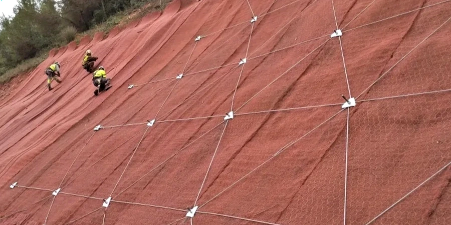
Stabilization and Reinforcement Design
When a slope does not meet the minimum safety factors, we develop stabilization strategies including soil nailing, mechanically stabilized earth (MSE), or regrading with benching, all calibrated to the caliche-rich stratigraphy of the Surprise area.
Construction Monitoring and Verification
During earthwork, we perform field density testing and bench inspections to confirm that cut slopes match the design geometry and that backfill materials meet the compaction specification, preventing future erosion rills from developing.
Common questions
How much does a slope stability analysis cost for a typical residential lot in Surprise?
For a single-family residential lot requiring a cut or fill slope evaluation, our fee typically ranges from US$1,320 to US$4,180 depending on slope height, site access, and whether subsurface drilling is needed. The final quote is based on the specific exploration program and modeling effort required by Maricopa County's grading review checklist.
What triggers a slope stability study under the Surprise building code?
The city adopts the IBC, which requires a geotechnical investigation for any cut or fill slope exceeding 5 feet in height, or where the slope inclination is steeper than 2:1 (horizontal:vertical). Slopes adjacent to structures, public right-of-way, or drainage channels typically face additional scrutiny during the plan review process.
Can our existing retaining wall design be verified with a stability analysis?
Yes, we routinely back-analyze proposed or as-built retaining walls. We model the global stability behind the wall to ensure that the reinforced zone, along with the retained and foundation soils, meets the global factor of safety for both short-term construction and long-term drained conditions.
How do you account for the caliche layers found everywhere in Surprise?
Caliche presents a unique modeling challenge because it acts as a strong, cemented layer when dry but can degrade into a weak soil when saturated. We map its continuity using test pits and CPT soundings, then assign reduced shear strength parameters to the caliche interface to simulate the worst-case scenario of perched water above this relatively impermeable stratum.
What is the difference between a static and a pseudostatic analysis?
A static analysis evaluates slope stability under gravity and normal groundwater conditions. A pseudostatic analysis adds a horizontal inertial force to simulate earthquake shaking, using a seismic coefficient derived from the site's peak ground acceleration and site class. For Surprise, this coefficient is often the controlling factor for slopes with a factor of safety close to 1.1 under static conditions.